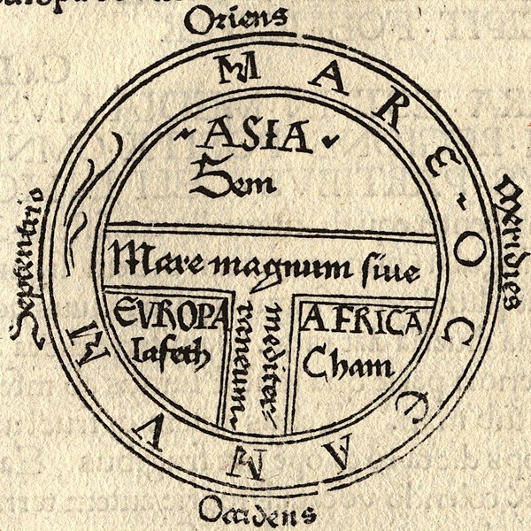
File:T and O map Guntherus Ziner 1472.jpg

Size of this preview: ༦༠༠ × ༦༠༠ pixels. Other resolutions: ༢༤༠ × ༢༤༠ pixels | ༤༨༠ × ༤༨༠ pixels | ༨༦༤ × ༨༦༤ pixels.
ཧུམ་ཆ་གང་། (༨༦༤ × ༨༦༤ པིག་སེལ་ ཡིག་སྣོད་ཀྱི་ཚད་: ༢༧༩ KB མའིམ་དབྱེ་བ་: image/jpeg)
ཡིག་སྣོད་སྤྱོད་ཤུལ།
ཡིག་སྣོད་འདི་ དེ་བསྒང་སྟོན་དོ་བཟུམ་སྦེ་ བལྟ་ནི་གི་དོན་ལུ་ ཚེས་གྲངས་/ཆུ་ཚོད་གུ་ ཨེབ་གཏང་འབད།
| ཚེས་གྲངས་/ཆུ་ཚོད། | Thumbnail | རྒྱ་ཚད་ | ལག་ལེན་པ། | བསམ་བཀོད། | |
|---|---|---|---|---|---|
| ད་ལྟོ། | ༢༢:༤༣, ༡༨ སྤྱི་ཟླ་བརྒྱད་པ། ༢༠༠༦ |  | ༨༦༤ × ༨༦༤ (༢༧༩ KB) | Ma xyz | Reverted to earlier revision |
| ༢༢:༤༢, ༡༨ སྤྱི་ཟླ་བརྒྱད་པ། ༢༠༠༦ |  | ༢༢༤ × ༢༣༨ (༡༨ KB) | Ma xyz | Reverted to earlier revision | |
| ༠༦:༣༤, ༡༡ སྤྱི་ཟླ་བརྒྱད་པ། ༢༠༠༦ |  | ༨༦༤ × ༨༦༤ (༢༧༩ KB) | Leinad-Z~commonswiki | Larger version, cropped from Image:T-O map 1472.jpg | |
| ༡༠:༢༥, ༢༤ སྤྱི་ཟླ་ལྔ་པ། ༢༠༠༥ |  | ༢༢༤ × ༢༣༨ (༡༨ KB) | Dbachmann | detail of Image:Etymologiae Guntherus Ziner 1472.jpg {{PD-art}} |
འབྲེལ་ལམ།
འོག་གི་ཤོག་ལེབ་ཚུ་ ཡིག་སྣོད་འདི་དང་འབྲེལ་བ་འདུག:
Global file usage
The following other wikis use this file:
- Usage on ar.wikipedia.org
- Usage on arz.wikipedia.org
- Usage on ast.wikipedia.org
- Usage on bcl.wikipedia.org
- Usage on be.wikipedia.org
- Usage on bg.wikipedia.org
- Usage on bn.wikipedia.org
- Usage on bo.wikipedia.org
- Usage on br.wikipedia.org
- Usage on bs.wikipedia.org
- Usage on ca.wikipedia.org
- Usage on cs.wikipedia.org
- Usage on cv.wikipedia.org
- Usage on da.wikipedia.org
- Usage on de.wikipedia.org
- Usage on de.wikibooks.org
- Usage on el.wikipedia.org
- Usage on en.wikipedia.org
View more global usage of this file.
