File:Bhutan CIA WFB 2010 map.png
ཧུམ་ཆ་ལེགས་ཤོམ་མིན་འདུག།
Bhutan_CIA_WFB_2010_map.png (༣༢༦ × ༣༥༠ པིག་སེལ་ ཡིག་སྣོད་ཀྱི་ཚད་: ༡༦ KB མའིམ་དབྱེ་བ་: image/png)

|
This map image could be re-created using vector graphics as an SVG file. This has several advantages; see Commons:Media for cleanup for more information. If an SVG form of this image is available, please upload it and afterwards replace this template with
{{vector version available|new image name}}.
It is recommended to name the SVG file “Bhutan CIA WFB 2010 map.svg”—then the template Vector version available (or Vva) does not need the new image name parameter. |
Summary
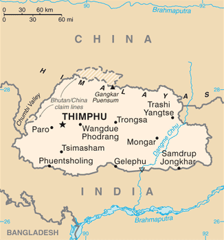
| Description | Bhutan map from CIA World Factbook (since June 24, 2010) |
| Date | |
| Source |
CIA World Factbook, converted from original GIF format |
| Author | United States Central Intelligence Agency |
| Other versions |
|
Licensing
This image is in the public domain because it contains materials that originally came from the United States Central Intelligence Agency's World Factbook.
|
 |
ཡིག་སྣོད་སྤྱོད་ཤུལ།
ཡིག་སྣོད་འདི་ དེ་བསྒང་སྟོན་དོ་བཟུམ་སྦེ་ བལྟ་ནི་གི་དོན་ལུ་ ཚེས་གྲངས་/ཆུ་ཚོད་གུ་ ཨེབ་གཏང་འབད།
| ཚེས་གྲངས་/ཆུ་ཚོད། | Thumbnail | རྒྱ་ཚད་ | ལག་ལེན་པ། | བསམ་བཀོད། | |
|---|---|---|---|---|---|
| ད་ལྟོ། | ༡༩:༤༠, ༦ སྤྱི་ཟླ་བདུན་པ། ༢༠༡༧ | | ༣༢༦ × ༣༥༠ (༡༦ KB) | Ras67 | cropped, opt. |
| ༡༡:༥༦, ༡༢ སྤྱི་ཟླ་ལྔ་པ། ༢༠༡༥ |  | ༣༣༠ × ༣༥༤ (༥༢ KB) | Evolt | Updated to version as of April 24, 2015 | |
| ༡༢:༡༧, ༢༢ སྤྱི་ཟླ་བརྒྱད་པ། ༢༠༡༡ |  | ༣༣༠ × ༣༥༤ (༡༨ KB) | Zyxw | =={{int:filedesc}}== {{Information | Description = Bhutan map from CIA World Factbook ([http://web.archive.org/web/20100704230847/https://www.cia.gov/library/publications/the-world-factbook/geos/bt.html since June 24, 2010]) | Source = CIA World Factbook, |
འབྲེལ་ལམ།
འོག་གི་ཤོག་ལེབ་ཚུ་ ཡིག་སྣོད་འདི་དང་འབྲེལ་བ་འདུག:
Global file usage
The following other wikis use this file:
- Usage on ace.wikipedia.org
- Usage on af.wikipedia.org
- Usage on als.wikipedia.org
- Usage on ar.wikipedia.org
- Usage on as.wikipedia.org
- Usage on bcl.wikipedia.org
- Usage on bh.wikipedia.org
- Usage on bjn.wikipedia.org
- Usage on bn.wikipedia.org
- Usage on ca.wikipedia.org
- Usage on cy.wikipedia.org
- Usage on da.wikipedia.org
- Usage on de.wikipedia.org
- Usage on de.wiktionary.org
- Usage on dv.wikipedia.org
- Usage on en.wikipedia.org
- Usage on en.wiktionary.org
- Usage on eo.wikipedia.org
- Usage on es.wikipedia.org
- Usage on eu.wikipedia.org
- Usage on fa.wikipedia.org
- Usage on fi.wikipedia.org
View more global usage of this file.