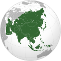
File:Asia (orthographic projection).svg

ཧུམ་ཆ་གང་། (ཨེསི་བི་ཇི་ཡིག་སྣོད་ ༥༤༡ × ༥༤༡ པིག་སེལསི་ཆུང་སུ་ཅིག་ ཡིག་སྣོད་ཚད་: ༥༥༧ KB)
This file is from Wikimedia Commons and may be used by other projects. The description on its file description page there is shown below.
Summary
| DescriptionAsia (orthographic projection).svg |
العربية: الخريطة الهجائية لآسيا English: Asia |
||||
| Date | |||||
| Source |
National Geographic. Map by Ssolbergj
|
||||
| Author | Koyos + Ssolbergj | ||||
| Other versions |
العربية: الرجاء، قراءة الميثاق.
বাংলা: দয়া করে, রীতিনীতিটি পড়ুন।
Deutsch: Bitte lies die Konventionen.
English: Please, read the conventions.
Español: Por favor, lea las convenciones.
Filipino: Paki-basa ang mga kumbensyon.
Français : S'il vous plaît, lisez les conventions.
हिन्दी: कृपया सभागमों को पढ़ लें.
Bahasa Indonesia: Silakan, baca konvensi.
Italiano: Si prega di leggere le convenzioni.
日本語: 規約をご確認ください。
ქართული: გთხოვთ, გაეცნოთ კონვენციებს.
Македонски: Ве молиме, прочитајте ги општоприфатените правила.
Português: Por favor, leia as convenções.
Русский: Пожалуйста, прочитайте соглашения.
Tagalog: Paki-basa ang mga kumbensyon.
Українська: Будь ласка, прочитайте конвенції.
Tiếng Việt: Hãy đọc công văn trước khi đăng.
中文(繁體):請檢視常規
中文(简体):请查看常规
|
||||
| SVG genesis InfoField |
Licensing

|
Permission is granted to copy, distribute and/or modify this document under the terms of the GNU Free Documentation License, Version 1.2 or any later version published by the Free Software Foundation; with no Invariant Sections, no Front-Cover Texts, and no Back-Cover Texts. A copy of the license is included in the section entitled GNU Free Documentation License.http://www.gnu.org/copyleft/fdl.htmlGFDLGNU Free Documentation Licensetruetrue |
- You are free:
- to share – to copy, distribute and transmit the work
- to remix – to adapt the work
- Under the following conditions:
- attribution – You must give appropriate credit, provide a link to the license, and indicate if changes were made. You may do so in any reasonable manner, but not in any way that suggests the licensor endorses you or your use.
- share alike – If you remix, transform, or build upon the material, you must distribute your contributions under the same or compatible license as the original.
| Annotations InfoField | This image is annotated: View the annotations at Commons |
India
Sri Lanka
Russia
Mongolia
China
Africa
Oceania
South Korea
North America
Europe
North Korea
Japan
Pakistan
Saudi Arabia
Kazakhstan
Papua New Guinea
Indonesia
Nepal
Iran
Cyprus
Kamchatka
Hokkaido
Cambodia
Turkey
Afghanistan
Bhutan
Philippines
Malaysia
Thailand
Vietnam
Captions
copyright status ཨིང་ལིཤ་ཁ
copyrighted ཨིང་ལིཤ་ཁ
copyright license ཨིང་ལིཤ་ཁ
inception ཨིང་ལིཤ་ཁ
༡༥ སྤྱི་ཟླ་གསུམ་པ། 2009
media type ཨིང་ལིཤ་ཁ
image/svg+xml
checksum ཨིང་ལིཤ་ཁ
172f5e66318d09590c698956d4edb40320c8ce53
data size ཨིང་ལིཤ་ཁ
༥༧༠,༨༥༠ byte
height ཨིང་ལིཤ་ཁ
༥༤༡ pixel
width ཨིང་ལིཤ་ཁ
༥༤༡ pixel
ཡིག་སྣོད་སྤྱོད་ཤུལ།
ཡིག་སྣོད་འདི་ དེ་བསྒང་སྟོན་དོ་བཟུམ་སྦེ་ བལྟ་ནི་གི་དོན་ལུ་ ཚེས་གྲངས་/ཆུ་ཚོད་གུ་ ཨེབ་གཏང་འབད།
| ཚེས་གྲངས་/ཆུ་ཚོད། | Thumbnail | རྒྱ་ཚད་ | ལག་ལེན་པ། | བསམ་བཀོད། | |
|---|---|---|---|---|---|
| ད་ལྟོ། | ༡༦:༡༢, ༡༠ སྤྱི་ཟླ་བཅུ་གཅིག་པ། ༢༠༢༤ |  | ༥༤༡ × ༥༤༡ (༥༥༧ KB) | ReneeWrites | Reverted to version as of 18:11, 29 July 2023 (UTC) - Vandalism |
| ༡༢:༠༢, ༡༠ སྤྱི་ཟླ་བཅུ་གཅིག་པ། ༢༠༢༤ |  | ༥༤༡ × ༥༤༡ (༥༧༩ KB) | Trantrongnam~commonswiki | Reverted to version as of 08:41, 15 March 2009 (UTC) | |
| ༡༨:༡༡, ༢༩ སྤྱི་ཟླ་བདུན་པ། ༢༠༢༣ |  | ༥༤༡ × ༥༤༡ (༥༥༧ KB) | Bennylin | synchronize with File:Southeast Asia (orthographic projection).svg. Source: File:United Nations geographical subregions.png | |
| ༠༠:༥༧, ༡༨ སྤྱི་ཟླ་གསུམ་པ། ༢༠༢༣ |  | ༥༤༡ × ༥༤༡ (༤༩༦ KB) | Golden Mage | A change to the map of Asia will first face debate from others. Hence, a change to the commonly accepted map of Oceania cannot be made without a wider consensus. | |
| ༠༣:༤༤, ༡༧ སྤྱི་ཟླ་གསུམ་པ། ༢༠༢༣ |  | ༥༤༡ × ༥༤༡ (༥༥༧ KB) | Kwamikagami | the Weber line divides Asian from Oceanic Wallacea | |
| ༡༩:༢༩, ༤ སྤྱི་ཟླ་དགུ་པ། ༢༠༢༢ |  | ༥༤༡ × ༥༤༡ (༤༩༦ KB) | Рагин1987 | Socotra repainted | |
| ༡༧:༢༠, ༤ སྤྱི་ཟླ་དགུ་པ། ༢༠༢༢ |  | ༥༤༡ × ༥༤༡ (༤༩༢ KB) | Рагин1987 | Final edit | |
| ༡༢:༤༣, ༤ སྤྱི་ཟླ་དགུ་པ། ༢༠༢༢ |  | ༥༤༡ × ༥༤༡ (༤༤༦ KB) | Рагин1987 | Correction | |
| ༡༣:༡༣, ༣༡ སྤྱི་ཟླ་བརྒྱད་པ། ༢༠༢༢ |  | ༢,༠༤༨ × ༢,༠༤༨ (༡.༠༤ MB) | Рагин1987 | Small correction (Socotra Island is geologically closer to Africa) | |
| ༡༧:༥༩, ༡༣ སྤྱི་ཟླ་བཅུ་གཉིས་པ། ༢༠༡༩ |  | ༥༤༡ × ༥༤༡ (༢༤༢ KB) | Goran tek-en | Added border for South Sudan as requested by {{u|Maphobbyist}} |
འབྲེལ་ལམ།
འོག་གི་ཤོག་ལེབ་ཚུ་ ཡིག་སྣོད་འདི་དང་འབྲེལ་བ་འདུག:
Global file usage
The following other wikis use this file:
- Usage on ab.wikipedia.org
- Usage on ace.wikipedia.org
- Usage on ady.wikipedia.org
- Usage on af.wikipedia.org
- Afrika
- Asië
- Europa
- Filippyne
- Irak
- Israel
- Japan
- Noord-Amerika
- Suid-Amerika
- Volksrepubliek China
- Thailand
- Singapoer
- Maleisië
- Afghanistan
- Sjabloon:Kontinente
- Bangkok
- Katar
- Taipei
- Indië
- Rusland
- Oesbekistan
- Hoofstad
- Lys van hoofstede
- Siprus
- Armenië
- Sjabloon:Lande van Asië
- Iran
- Egipte
- Wikipedia:Sjabloon
- Turkmenistan
- Wikipedia:Lys van sjablone
- Britse Indiese Oseaangebied
- Suid-Korea
- Noord-Korea
- Antarktika
- Beijing
- Gondwana
- Eurasië
- Laurasië
- Kategorie:Lande in Asië
- Libanon
- Jerusalem
- Azerbeidjan
- Bahrein
View more global usage of this file.
མེ་ཊ་གནས་སྡུད།
ཡིག་སྣོད་དེ་ནང་ ཌི་ཇི་ཊཱལ་པར་ཆས་དང་ ཡང་ན་ པར་ལེན་འཕྲུལ་ཆས་ནང་ལས་ཁ་སྐོང་འབད་ཡོད་པའི་ གསར་བཟོའི་བརྡ་དོན་ཚུ་ཡོད།
གལ་སྲིད་ ཡིག་སྣོད་འདི་ སྔར་བཞིན་མ་བཞག་པར་ ལེགས་བཅོས་འབད་བ་ཅིན་ ཁ་གསལ་བཀོད་མི་ལ་ལོ་ཅིག་གིས་ལེགས་བཅོས་འབད་ཡོད་མི་ཡིག་སྣོད་ ཆ་ཚང་མི་སྟོན་འོང་།
| Width | 541.48 |
|---|---|
| Height | 541.48 |


